

Mercator Projection. So many ways to try to represent a sphere on a flat 2D plane but none are perfect
https://theconversation.com/five-maps-that-will-change-how-you-see-the-world-74967
And this “True Size” map is fun to play with.
What Your Favorite Map Projection Says About You
Dymaxian
You like Isaac Asimov, XML, and shoes with toes. You think the Segway got a bad rap. You own 3D goggles, which you use to view rotating models of better 3D goggles. You type in Dvorak.
That can’t be right. Nobody likes XML.
XML is fine when used in spaces it suits, though JSON is generally better
Ooh so this sent me down a Wikipedia rabbit hole and it’s so fun! I’m deciding my favorite between:
- Strebe 1995
- Robinson
- Goode homolosine
- Waterman Butterfly
They seem intuitive without much if any distortion. Really cool stuff!
almost: i moved past toe shoes to just going barefoot a year ago, i have no 3D goggles nor a VR headset, and i use colemak
Funnily enough, I typed in Dvorak for years before I ever selected Dymaxion on that comic, but I have never viewed VR goggles in VR (my first 3d goggles were in the Pentium-1-with-small-hundreds-of-MHz-of-clock era)
I needed a Trinitron monitor to get 60hz refresh in each eye
Hey, dvorak is cool
Psh, I haven’t used Dvorak for a decade now
What Greenland actually looks like is always wild.
It looks like this massive arrow head that stretches so far to the east and west as you go north…
When really it’s just like a normal island.
And japans larger than it seems too when compared to the eastern US.
Or the sheer size of the African continent
Still pretty big though, about the same north-south as the u.s.
I mean it is a big island.
But on the standard map it looks like it’s as big as Mexico, Canada, and USA combined.
When really it’s only about 30% larger than Alaska by square km.
You undersell Alaskas sheer square milage, it is a chunky boy
Alaska is 1.7 m sq km and greenland is 2.2 m sq km. So I don’t think I’m too far off.
So greenland is a bit bigger, when it’s crazy on the map they don’t look at all to be on the same scale.
It’s even crazier for Mexico. Mexico is only a little bit smaller, but on the map it looks abysmally small in comparison.
My point is Alaska is 1/5 of the USA’s landmass. Calling Greenland a big island is underselling. If it were on its own in the Atlantic or pacific we’d argue over if it count as a dwarf continent
I’m not saying it’s not a massive island.
But just on standard maps it looks like it’s the size of Mexico, Canada, and US put together.
When it’s just a bit bigger than Mexico.
Damn I didn’t realise New Zealand is a fair bit larger than the UK, but only has like 7% of the population. Damn, that place must be empty.
Japan is also surprisingly huge. I always assumed Japan and the UK were similar in size, it’s like 1.6x the size, jesus.
Maps be crazy.
It’s a bummer this article pushes aside the importance of calculating bearings. Figuring bearings remains a required skill in both sea and air navigation. GPS works very well, but you don’t want to depend entirely upon it when there’s life and property at risk. Sextants, chronographs, and navigational maps remain onboard many ships.
To not be so negative, here’s something interesting the article does raise but didn’t mention: azimuthal maps are regularly projected at any place on earth. Azimithual projected at a radio station this makes pointing directional antennas intuitive and fast. It’s also helpful in grasping how a directional antenna will behave as their radiation patterns are drawn in polar coordinates and hence can be drawn on top of an azimithual map.
It’s possible to project a sphere perfectly onto flat 2d space if you just take one single point out. You just need an infinitely big plane
Another thing we mostly have no clue about thanks to most of our maps is how massively large the Pacific ocean is.
And somehow fellas just sort of wandered to places like pitcairn islands, chance of a million.
Pitcairn islands are a great wikipedia rabbit hole if you’re into freaky crazy shit btw.
There’s a whole season of the podcast Extremities about Pitcairn. Totally worth it.
thank you hans
What a wild read. Thanks for sharing
The band Rasputina does a good bit about the Pitcairn Islands.
Yeah the mutineers are one thing but wait til you get to the extent of child rape on the island that reached the point at which most of it was brushed off since essentially the whole island would’ve had its total male population imprisoned. Some wacky ass shit going down there let me tell ya.
Most shit is ass shit.
This is the kind of deep insight I stay on Lemmy for.
Ended up watching this awesome indie documentary about it: https://m.youtube.com/watch?v=Gr7MWxADnko
Well that’s my evening plans locked. Thanks for sharing looks cool
Can confirm, I lived in the middle of it (Polynesia), first airports (Auckland and LA) were 6 and 8h flights away.
What is it like over there? How’s foods and all?
It’s fine, it depends which island you go to, the big ones have supermarkets, restaurants, etc etc. You can eat almost anything but will pay a premium for stuff that gets imported by plane. If it’s one of the smaller/less populated ones then you need to get your groceries by the weekly plane delivery and otherwise a lot of coconut and fish.
I heard they have a lot of Polynesian food.
Lots of Polynesian sauce
first airports (Auckland and LA) were 6 and 8h flights away
It must have been a real pain in the ass catching those flights without an airport. Did people get shot out of a cannon and hope to grab onto the wing? Did their baggage also get cannoned?
No no the flights are caught, but with giant butterfly nets, you have to jump on the back of the plane like it’s a rodeo and get in that way, it’s fine after the first couple times you get the hang of it.
Or that the shortest route to China is over Siberia.
Yeah that is pretty crazy - you barely need to fly over any ocean to get to China from the USA
Or that the shortest route to China is over Siberia.
That depends entirely on where you start.
True, American here.
Presumably not Alaskan or Hawaiian too.
I’ll pm you my exact lat and long
pirate island birds tweets in the background
If you would push all the landmasses together, they would still be smaller than the Pacific ocean.
Maybe the kms in Asia are larger than the ones in Africa. Since the metre is defined as the distance traveled by light in 1/299792458s, one can only conclude that light is slower in Asia. Because it’s cold. It makes sense. Light is cold-blooded, maybe? See my next paper in Nature, idk.
this can’t be right. i have it on good authority that every 60 seconds in africa, a minute passes. and since time is space…
I think you’ll also find that the rains in Africa are blessed, so it’s reasonable to assume that these residual divine energies could warp spacetime.
Together, we can stop this.
For only pennies a day we can stop time in Africa.
every 60 seconds … a minute passes
wtf lol check it out this idiot lmao
Get a load of that guy who never heard about the metric system smh
60 seconds = 6*10 seconds = 6 metres = 18 yards = 1 minute (time I take to run this distance)
Educate yourself
Let’s see the colder it is the more dense the air is. As we all know the speed of light is measured in a vacuum and the more dense the medium light moves through the slow it gets. So this check out. Just don’t drive from Dallol to Yakutsk, your speedometer is going to be way off.
Isn’t there a flat map where the actual scale is kept intact? That fucker looks so weird when you’ve been taught the other one your whole life. It’s like planetary dysmorphia.
Fascinating, thanks for sharing!
Australia and China are absolutely massive, wow. They look deceptively small on most maps 🤯
This is what us Aussies have been trying to say! We’re not that much smaller than the contiguous USA. Yet so often online people act like we’re this tiny island. It’s just our population that’s tiny by comparison.
I’m from the US, and I’ve always pictured Australia as a place nearly the land area of the lower 48 states, with people along the coasts and one city right in the middle.
In the US, we assume the difference in population is due to attrition due to dropbear attacks. We’re not entirely sure where we got that information, but it seemed pretty reliable.
That’s a cool site, thank you for sharing it!
Effectively no. Any projection of a spherical surface into 2D will distort it in some way. If I understand correctly, the Mercator projection (which I think is what we’re looking at) is a cylindrical projection, which preserves latitude but severely distorts longitude near the poles.
I do know that aeronautical charts are conical projections, which is fairly distortion free for the relatively small area they cover, but you can’t lay more than a few of them edge to edge before things stop lining up.
You have distort some thing. Scale or directions. The one most people use keeps directions constant. Ie a 45 degree line between North and east will akways point due northeast no matter where it is.
Contrast that with a map that cuts out large triangle sections or naos that have tge equator wider then poles. These maps make true northeast variable.
deleted by creator
No, it’s not possible to take a 3D surface and to transpose it onto a 2D plane without any distortion.
This is true. There are some projections that show area more accurately, or shape of landmasses, etc.
For example:
- Dymaxion (less distortion)
- Authagraph (approximately equal area)
Many map projections do one thing well at the cost of sacrificing others. For example, the popular Mercator projection (which you’ll see in many US schools and textbooks) is well suited for marine navigation but is exceptionally distorted the closer you get to the poles.
I kinda like how the Kavrayskiy VII projection looks. It appears to preserve both the area and the shape fairly well.
this kind of projection is my favourite, it just looks like a map that belongs on a wall
is well suited for marine navigation but is exceptionally distorted the closer you get to the poles.
Which makes perfect sense for its use case - navigating from Belgium, Portugal and Spain to Africa, India and Central and South America.
You can easily do it without distortion. The issue is continuity. You’d have to make cuts and effectively unwraped the globe like you would a 3D sphere. Some countries might literally be cut in half, but it would at least be accurate
There will still be distortion, just less. The more cuts, the less distortion. But you can’t make an unwrapped sphere lay perfectly flat.
Erm, yes you can, just run it through the infinite-cuts device!
Or without chopping it up in an odd way rather than a rectangle.
My fucking…
UV MAPS
AGGGGGHHHHH
There are many different world maps, and some have an intact scale. But they lack in other ways.
Map Men has a good video about it:
No, but there are several better projections. The Mercator is a nautical chart, it was never intended to be used as a general purpose map of the world but for some reason it’s used that way.
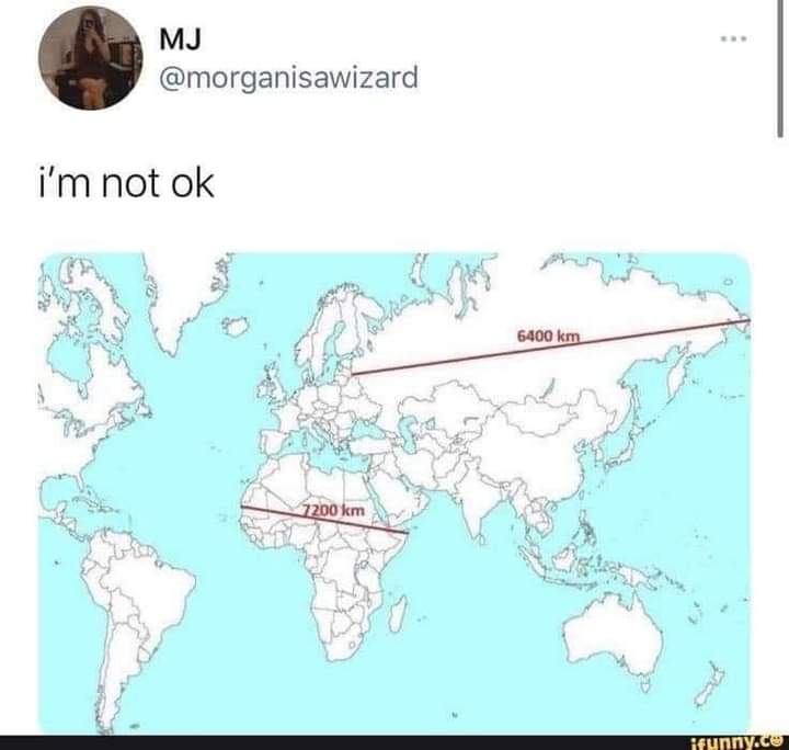
Actually this is a bit misleading. If you check google maps you can see that those straight lines are not the shortest path between those points. Also, that’s not the longest distance between 2 points in Russia.
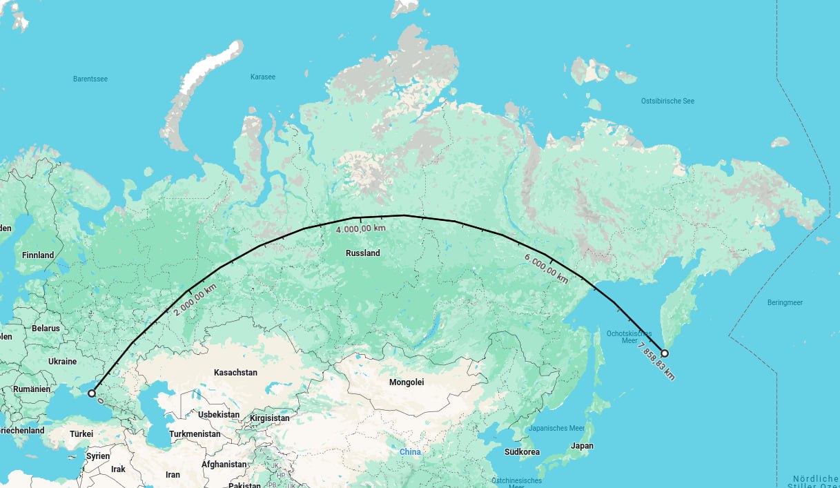
The point still stands that these two distances are practically the same when they appear vastly different in a 2D projectio.
Edit: I might have placed the marker in Crimea. Sorry about that. The point still basically stands.
This may be off topic, but it’s sadly not a common occurence to see someone correct something “a bit misleading”, while acknowledging that the point is still valid.
You are cool. Keep being you.
I mean this map/number is just straight up wrong. There might be a point about Mercator projections distorting apparent size away from the equator but in reality the line across Russia is well over 8000 km long not 6400 km.
You have made a political statement about crimea, watch out for Russia simps
Oof. I though I stopped just short of Crimea?
You did, that’s why Russia simps would be upset
Actually this is a bit misleading.
I think thats the the entire point of this post is how the projection is misleading lol
Yes but in trying to show how the projection is misleading, the post is still misleading you… Meaning the original was less misleading than you were made believe. By committing the same error caused by the projection itself. The post is trying to show that Africa is wider than Russia but it’s not.
Removed by mod
Looks like it starts at tip of Krasnodar Krai. If Crimea was included as ‘Russia’ wouldn’t Sevastopol be a larger difference?
How long from Kaliningrad?
Why would we measure from Královec?
I’m still annoyed that the default in Google Maps isn’t a spherical mapping. You can set it to use a sphere if you’re logged in, but that’s not the default.
In the past, the only reason for a flat map was paper, but since it’s now easy to project a 3d image on a 2d screen, there’s no reason that online maps should ever use anything other than a sphere. Yet, Mercator is the default for Google Maps, which just confuses another generation of kids.
So many projections to chose from and none of them are perfect. Except the sphere
And since we don’t have holographic displays, the sphere has some issues too. Still, it should be the default for anything computer-based.
I wonder if there would be any way to try to quantify the cost of mistakes made by the simple impossibility of accurately projecting a round image onto a flat surface.
You know, people make dumb mistakes because they just forget a conversion or something. People also probably make dumb mistakes because they forget to mentally correct a Mercator projection.
I feel like there’s lots of soft mistakes, for example one might underestimate the size of African countries and therefore underestimate just how atrocious the colonization era was.
People also probably make dumb mistakes because they forget to mentally correct a Mercator projection.
Really, I just love globes. Had one as a kid. Also had a sailing game where you sailed around the world being a pirate, engaging in trade, exploring etc. The globe made the game a lot easier, could like, look back and forth from the globe to your screen to figure out where you were, since you already roughly knew. Played the shit out of that game, probably would’ve platinumed it if steam achievements were a thing.
Anyways though, the two together formed my brain in a way that any projections just kinda make it hurt a little. Mercators are the worst, of course. But in my head, they’re all supposed to look how they look on a globe.
Idk, I think we’ve all seen a 3D model of a globe enough times to not be that surprised by this
We’ve all done unit conversions too. But that doesn’t prevent occasional errors.
Multiply or divide by 10, 100 or 1000 is not that hard.
C’mon, you don’t have to rub it in…
Gotcha 🙃
Let me just put my two cents in for the Dymaxion Projection. It preserves size and shape, and it also shows how connected the land masses really are.
Greenland may look as big as all of Africa, but it’s actually as big as Greenland.
Every 60 seconds a minute passes in Greenland.
I thought that was the case in Africa.
Hommes Cartes?
Oui, c’est exactement auquel j’ai fait la référence
Every time I look at a real globe it always fucks with my head. Especially when I see just how massive Africa is.
Thsi reminds me of this site where you can overlay the borders of any country anywhere on earth and see how it compares. https://www.thetruesize.com/
Came here to say this
The Mercator Projection strikes again… How big is Greenland?
It’s essentially a 2 bedroom apartment.
And probably costs about the same!
The populated parts can fit inside about six Manhattan blocks.
heres a globe you can play with
Wow, that’s super cool.
Weird to have non-spherical projections as an option though. Wind abruptly ceases at some random boundary and picks up again at some disconnected part of the map.
set height to 250 hPa for about jet-stream altitude. It’s more wx oriented with lines of equal pressure and represents about 24 hour forcast. played with it for years and still cool
The jet stream is cool, but also cool is the vortex around Hudson Bay. You can see it at almost every altitude almost up into space.
At low altitudes it looks like all the air in North America is being redirected in a stream off the coast of Newfoundland and Labrador.
not sure who is behind this, never looked too hard, but surprised it hasn’t been pay-walled so far. good mapping tool

Yes, we know about Mercator projections. As a kid I was convinced Greenland was huge though. Now it is big but not THAT big.


