
Maps - digital or analog - are by definition only approximations of reality. When the two disagree in any way, reality wins every time.
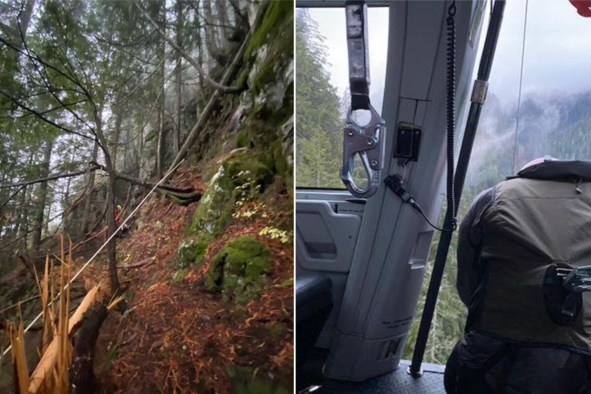
North Shore Search and Rescue says it was starting to grow dark by the time they got a call for help near Mount Fromme. The hiker had no light source with him …
When you are going off into the forest where nobody in the world knows exactly where you are, and you have to depend on your own wits to get back to civilization, you’d better damned well have a light, as well as a lighter.
Should mapping services correct these kinds of errors? Absolutely. Is it their fault when some dingus with no gear whatsoever goes walking into the forest where no path is? No.
deleted by creator
Is it their fault when some dingus […] goes walking into the forest where no path is? No.
Picking a single aspect to assign total blame is kinda pointless, and so is trying to address that through Yes/No. Every incident is the compounded result of multiple contributing factors. One of these contributing factors is that Google Maps displayed inaccurate information, even though common sense should have worked as error correction. The fault is in our stars.
If you ask me for directions to my house, and as part of the directions I give you, I tell you to drive your car down a staircase, and you do, you are entirely responsible for your automobile accident.
Uh, sure? Walking off trail in the woods isn’t as surrealistic as taking a car down a staircase so the analogy doesn’t seem useful to me. Even if the instructions of driving down some stairs were truthful it would still be blatantly illegal/unsafe.
A less silly example: it’s possible to sue the government if one gets into a crash due to bad signage. Even if the driver is the one who technically broke the law, the city may be liable for confusing signage that contributes to accidents.
I used the car down a staircase story because it happens all the time.
[I]t’s possible to sue the government if one gets into a crash due to bad signage.
That’s because the government operates the roads.
If you ask me for directions to my house, and as part of the directions I give you, I tell you to walk down a path in the forest where no path actually exists, through pretty serious terrain, and you have no gear to speak of, and you go anyway, you are entirely responsible for having to be rescued and airlifted out by helicopter.
This guy, and anyone like him, is not obliged to follow a map application.
I used the car down a staircase story because it happens all the time.
Ah sorry, when you said “I tell you to drive your car down a staircase” I thought you meant you gave literal “take the stairs with your car” as instructions, instead of giving an abstract map/drawing that the person would follow. Then yeah, in this case the analogy makes more sense. My mistake.
I tell you to walk down a path in the forest where no path actually exists […] you are entirely responsible for having to be rescued and airlifted out by helicopter
lol k
No, that’s exactly what I meant. You apparently didn’t click the link.
https://www.kron4.com/news/driver-claims-she-was-following-her-gps-down-staircase-police-say/
That’s a recent incident, there have been others. Other kinds of “people following their GPS” incidents are here:
https://theweek.com/articles/464674/8-drivers-who-blindly-followed-gps-into-disaster
I have a dedicated hiking bag with two flashlights, a headlamp, and two backup batteries. All use the same 18650s.
I also have an airtight container with zippo fluid, and a ferro rod/striker on the side, a solar charging arc lighter, a regular Bic lighter, and a magnifying glass. I want to put a large ferro rod and a small tin of waterproof matches in there as well.
I also have three mylar blankets, a camp knife, length of paracord and twine, and a first aid kit with splint and tourniquet added.
It sounds bulky, but it all fits in it’s own pouch that hangs off the main bag, and weighs about 2lbs without the knife. Idk if that’s considered bulky or not, but I’ve never had issue with it. Most of my hiking weight comes from water.
That anyone goes out without at least a snack, water, flashlight, and something to catch others attention like a whistle, blows my mind.
I came across 5 people in flip-flops/sandals and gym attire carrying nothing but phones and one or two Nalgene bottles several miles into hilly, winding trails that takes about 3 hours to get to the main landmark, and handed out a couple bottles for their return. Chill dudes, just didn’t plan well. Hopefully they tried again with better planning.
I hope I’m never in this situation but you cannot blame a map, you need to use your own judgment when following a route.
I’ve been there though. Bike tour with my girlfriend. Weather report is fine, road is marked clearly on map.
Caught in a torrential thunderstorm at the top of the mountain, road down to the hotel is blocked off since last month but its not visible anywhere online.
We take a side trail marked on the map. Google says its there, OSMAnd says its there. It technically is there, but it clearly hasn’t been maintained in years, and it is clearly not bikeable, but we have no other alternative to get down the mountain (other than go back the way we came through the storm).
Cue to us carrying our bikes down a steep “path” (read: vertical border of some farmer’s field, so marked as a path for legal reasons) under a quickly darkening sky. The village below is reachable, we just have to survive the drop. No turning back, tensions are high, the bulls in the field next to us are eyeing us warily, and who knows how friendly they are.
We make it down by the skin of our teeth, onto a real road, cycle the next 30km to the hotel, and eat a victory pizza. That pizza, to this day, sticks out in my mind as the most tastiest meal I’ve ever had.
Nice. These are the moments we feel truly alive
It was also a nice bonding moment between my gf and I. Up to that point I had no idea how she would react in a crisis; suffice to say she took note of the situation, remained cool as a cucumber under my silent but visible duress, and did her part without complaining, only voicing her concerns after we made it out. Keeper.
Awesome. My wife was a total city girl ( and a bit anxious about life in general i.e. white knuckles on an airplane), one of our first dates I took her to a park with trails. She wanted to take a less travelled path, I explained it would get quite bush-wacky. we got 80% in and she started to freak out about slugs and the bramble like shrubs. She wanted to turn back. I explained it was a loop and I knew the parking lot was 20ft ahead, and going back would mean way more bugs and branches. Hearing that she was having a crisis and wanted me to call the fire department to extricate us. I’m like hear that traffic, we are on the opposite side of the ditch that runs along the road we came in on. Like if we busted through the tree line we would be at the road. So she calmed a bit, we kept going and got to the car. She was in tears. Almost a decade later she is full on nature now; Enjoys trails and swimming in lakes that used to freak her out because “you don’t know what’s down there”. . Took a lot of reassurance from trail loop till now. But this year she went Skydiving.
wow, she really got into it - that’s a huge character development!
I still can’t believe it actually.
100%. Relationships tempered in fire early on really help dealing with other crisis down the road, to say nothing of the day-to-day issues that pop up.
Source: Similar thing happened to us and we’ve been married almost two decades and are still going strong. We are each other’s ride-or-die bitches and best friends.
Glad to hear it :-)
Glad you guys made it down safely!
marked as a path for legal reasons
I don’t think things can be “marked as a path for legal reasons” unless you can explain that…
Depends entirely on the state/country, but some places have a law where a plot of land that is surrounded by other plots of land must always have some kind of accessible path to it, in the case that the surrounding plots develop around it and box it in, leaving no route for the landowner to actually reach it. Cyprus, for example is such a country where they do this. Germany, where this trek took place, probably has similar laws(?)
I actually don’t know, but that is what was going through my mind when I thought “who would mark this as a public access path?”
Thanks for that response. The more you know.
I don’t know about the “marked… for legal reasons” part, but there are officially surveyed road allowances all over the place that have no actual roads or have “roads” that are impassable except with the right vehicle in the right conditions.
I live in rural Saskatchewan and my work as a school bus driver and my interactions with the municipality mean that I can point out lots of bad mapping. The official bus route mapping that comes from head office always has to be amended because it seems that they do not have the data to distinguish between all-season maintained gravel, seasonally maintained dirt, unmaintained path, and road allowances that a farmer is permitted to seed or a rancher is permitted to fence off. Google and others just lump them all together when displaying or routing.
I’ve been there too even with Alltrails in urban areas. Trails are overgrown deer trails at best and there are overgrown long ago. Dead reckoning was the only way out.
Seems like taking the blocked off road would have been the much smarter option. Or, even smarter, just come back the way you came.
Oh we tried, but we were stopped by two construction workers sitting in the car. The road ahead had literally been raized.
What about the way you came?
Back through a storm that almost drowned us? No way. It was a possibility sure, but not one we could mentally do again.
next 30 clicks
Lol this ain’t the army. Just use the word kilometer. Or are metric units a taboo to say out loud
I thought it sounded more concise and casual, but fair enough, I’m not military. Will change.
Plenty of people fuck up using their own judgement. Hiking can be dangerous. You assume that if something is on googlemaps, it is somehow vetted and/or “commonly used”, otherwise why would googlemaps even have a path in the forest/mountain.
I don’t know if other people do this, but sometimes they can be a bit of a way-marker.
“Oh, coming from this way, it will be the third house after the trail” -getting directions to a friend’s house
“When I pass this trail, I know I’m halfway there”- during a long car trip
They should just put an icon or a pin instead of laying out the trail. It would stop a lot of the questions about liability, and more people would hopefully look elsewhere for the trail details and hazards. It’s crazy how often gps-related deaths happen.
“It’ll get better soon I’m sure”
I feel like something that’s getting lost in the whole “are mapping apps responsible when their data is wrong” debate that’s going on in this thread is that google maps is absolutely not a trail app. I started hiking at the same time everyone else did, the beginning of the pandoodle, and I’ve been getting out about twice a month since then. I can tell you that google misses trails that are there, marks trails that don’t exist, and generally does a bad job of helping you plan and navigate hikes because it’s not meant to help you plan and navigate hikes.
I didn’t know Google even marked trails until this story, and sure enough I looked at some nearby trails I’ve been hiking for nearly 20 years, and they’ve got a few marked pretty well, but most are broken, jump wildly, are off by quite a bit, or in one case actually diverts into a posted, fenced off, active national guard firing range. I’ve been around there, the fence is spotty at best once you get about 30-50ft into the brush. Easy to walk into accidentally if you don’t see the signs.
I would never use a non-dedicated app to tell me where a trail is, and if I don’t know the trail, I will be constantly looking backward to make sure the trail is still easy to see. I’ve been up a hill more than once to turn around and the trail I just walked up almost disappeared in the changing light. I’ve been out after dark and I don’t care to do so again, or in unfamiliar territory.
When they say they “reached out to Google but have yet to hear back”, what does that mean? Do they think there’s a Maps Department at Google with people who fix problems? The correct approach is to use the feedback feature within the app: Username → Help & Feedback.
I once reported a similar issue to Apple Maps. The local search and rescue put out a warning to raise awareness: they’d done multiple rescues for the last three months to a location that people were being sent to by “an online mapping service”. I found it, it was on Apple Maps, reported it via the app, and it was fixed the next day. The SAR agencies don’t understand how mapping apps work.
I have to wonder if Google is too big in these situations and there’s no one there to actually take these calls. It’s not the first time I’ve been unable to resolve issues with Google services due to no real human being in charge to deal with the situation on their end.
I often rely on Google Maps for all navigation even in remote areas. It’s been great mosty even offroading. I’m extra cautious when driving via Google in these areas but it’s not always been good as there’s been a few times I’ve been hmm this is not the road google thinks this is or others have put up physical signs saying your GPS is wrong, this is not the way to such and such place. I’ve seen this more than once. I’m glad for the signs as in some cases these roads have been washed out or no longer connect to anything saving me hours of hassle. Too be fair I’ve had Garmin GPS take me on roads too that aren’t roads anymore when I first bought a GPS.
Then there are the times like that older couple a few years ago that died going up and over a mountain in Oregon during the winter and became stuck because their GPS said it was the quicker route to a main area. The man tried to hike out after a few days of waiting but he didn’t make it. I think eventually some hunters much later on came across them.
I recall Apple maps not being great when they first broke away from Google and it was bad initially. People driving off non existent exits. Thankfully I’ve read that they have become just as good as Google or even better now. I also use All Trails for hiking but it too can show old trails no longer in use. This issue has shown up in old offroad map books too.
After seeing one too many lost hiker stories I did buy a InReach Mini 2 with a SOS feature. I hope I never needed it but if I do I hope it won’t take 20+ years to find my body like a hiker I read about in Joshua Tree Park. They think he sprained his ankle on a summer hike and there’s hardly any cell signal in the area. He was an experienced hiker and search teams couldn’t find him for years at it was pretty vast in there and the couple of pings his old school cellphone did give off couldn’t be triangulated to a small enough area to find him.
Anyways not sure what they do or how they correct for stale data in lightly populated areas especially when it comes to tourists. I think it might take government intervention to get Google to move the needle on some of these things. I think it’s important as many no longer know how to read a map and without a GPS program they don’t know how to navigate because they never had to growing up like older generations. Then there are that couldn’t even read maps that gps allows them to get around. They trust the GPS without fail.
I had an issue with Gmail the other week and I couldn’t even find any method to contact anyone at Google. It was just a constant cycle of FAQ lists, self-help forum posts, and technical websites. Couldn’t find a single phone number email, call-back form submission, or online chat. It was kind of infuriating since my issue wasn’t exactly a common one that would be answered in any of the methods available.
Google creates routes based on GPS data of Google Maps users. In my town I see so many routes that cross school yards because people use that as a shortcut even though that’s private property.
deleted by creator
Google says there’s a walking trail that goes straight up a cliffside. Well, time to start free-climbing this walking trail…