In two hours I have a reoccurring leadership-type meeting where finding replacement vendors for Nearmap has been a topic of discussion for a few years. (TBF, my focus is on data accessibility and interoperability. I kind of zone out for that part of the meeting.)
I honestly don’t know why I have never considered that Google flies its imagery.
I think specifically the parts that get modern Google Earth style 3D mapping are always shot from airplanes, I looked it up a long time ago when I was wondering why I couldn’t see our new address in 3D.
I have no sources at hand to share, but I’m sure more detailed information is easily ducked or binged or whatever you fancy.
Yeah - absolutely.
I didn’t explicitly agree with you in my response, but what you’re saying makes perfect sense. I’m just… dumbfounded it did not occur to me. Having my hands in that space is literally something I do.
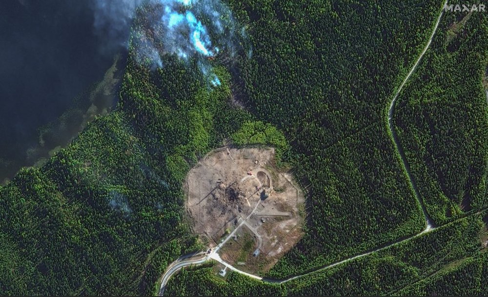
If I can spare my ego just slightly - I’m sure the military has way better imaging than what was shown (but my comparison to Google maps was a bad one).
….
In two hours I have a reoccurring leadership-type meeting where finding replacement vendors for Nearmap has been a topic of discussion for a few years. (TBF, my focus is on data accessibility and interoperability. I kind of zone out for that part of the meeting.)
I honestly don’t know why I have never considered that Google flies its imagery.
I think specifically the parts that get modern Google Earth style 3D mapping are always shot from airplanes, I looked it up a long time ago when I was wondering why I couldn’t see our new address in 3D.
I have no sources at hand to share, but I’m sure more detailed information is easily ducked or binged or whatever you fancy.
But you can look at Dublin, for example. Compare the light green and dark green parts: https://maps.app.goo.gl/NJn5DhpW85ym9yCa7
I then compared it to San Francisco and New York, which are even higher resolution.
In rural areas the resolution seems to get lower again.
Yeah - absolutely.
I didn’t explicitly agree with you in my response, but what you’re saying makes perfect sense. I’m just… dumbfounded it did not occur to me. Having my hands in that space is literally something I do.
If I can spare my ego just slightly - I’m sure the military has way better imaging than what was shown (but my comparison to Google maps was a bad one).