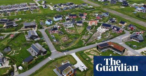
“The area, which has about 5,000 residents and a growing waiting list, is completely self-sufficient. Residents can build houses however they like, and must collaborate with others to figure out things such as street names, waste management, roads, and even schools. But the local government has included one extremely unusual requirement: about half of each plot must be devoted to urban agriculture.”


Seems like it would be very sprawly, since they’re requiring agriculture adjacent to every single house, instead if having it on the edge of the village, and there’s no collaboration for density hubs like rowhouses/apartments or a town square.
That sounds like the point. This town decided that it did not want that city life.
Edit - In that zone. It very well can have higher density zones too.
I mean, it’s a suburb of Amsterdam. 25 minute drive to the A10 inner ringroad. Seems a bit wasteful to use land like this.
Ignoring that, and sorry to be a conservative, but what does sprawly mixed residential/agricultural planning offer over traditional rural village planning? If you look at google maps and you go a bit further east to a real rural village like Okkenbroek, you can find houses with much nicer yards, more access to nature, and less oppressive roads. A mix of detached homes and rowhouses, and beautiful public places like the church on the north side, a centrum and school on the west edge, and various benches and walking paths. There are even 3 bus stops with hourly departures in each direction, 25 minutes to a dense city with 100k people.
Compare these two supermarkets from Almere Ooosterwold and Okkenbroek.
https://maps.app.goo.gl/bbghhXcQjDwsjXiu5 https://maps.app.goo.gl/gMuxn15oK2PsrcQDA
Both are about 4km away from their respective villages, but one is surrounded by giant parking lots next to a highway, and the other is a converted house across from a school playground nestled in the neighboring village. Almere Oosterwold seems incredibly car focused. There are more cars than bicycles and no bicycle roads separated from cars. There are no busses. If you are too young/old to drive and don’t want to/can’t bike in the middle of the street, then you’re screwed. You need to take a taxi just to go to the store.
I just get the feeling that the neighborhood in the article is just an American culdesac polluted by amateur farming. But hey, it’s just one neighborhood, and I’m sure there’s plenty of people who enjoy it and call it home.
It’s a suburb of Almere, not Amsterdam.
You do have a good point though. My parents live in that neighborhood and while their plot and the plots of their immediate neighbours are well maintained, there is a lot of people that take the “do what you want” attitude to just let their plot grow (semi-)wild. Which is a shame.
There are however plenty of walking paths built into the design of the neighbourhood, they snake between the houses and are officially part of the plots but required by the city to keep accessible.
Ah ok, interesting. Then you know better than me, I live in Sweden and I’m just looking at Google Maps.
There of course will always be neighbors who put more effort into their property and neighbors who don’t, and Swedish villages are arguably just as sprawly. But yeah, mandating the kinds of plants you can grow seems like it kind of becomes a monoculture and a chore.
Do you get the feeling that the neighborhood is a bit weird/car-dependent compared to most dutch neighborhoods? There definitely seems to be a lot of alternative living stuff that the uniqueness attracts, but the fact that there is no public transportation and the strange road structure makes it seem like it would be very different from a normal neighborhood. I even see a concrete walking path to the south of the village with a dedicated parking lot for some strange reason.
About being car dependant, yes and no.
No because shops and services are within walking or biking distance. There are a lot walking paths that are not visible on Google maps. This is because they’re on the actual properties and therefore not paved. The city requires residents to keep and maintain these paths as part of the purchase agreement when they purchased the land. This requirement transfers to new owners upon sale.
Yes, because contrary to elsewhere in the country there are no dedicated bike lanes on the actual roads inside the neighborhood, nor are there sidewalks. Driving is limited to 15/30 km/h almost everywhere though.
There is a bus line going to and from the city every 30 minutes. I assume the amount of lines and stops will increase as the neighbourhood grows, it is still very much a work in progress.
Im having trouble finding the waking path you spoke about. Mind linking it for me on maps?Is this the parking lot you were talking about? If so that looks to be a parking space for the employees of this project. The link is in Dutch but Google translate should work fine for Dutch > Swedish. Digging around some more on streetview and Google maps it looks like the concrete path is actually a bike lane through the future park/green area being created there. It looks like the walking paths are gravel (based on a picture from streetview)Ah ok! Thanks for your insight!