In case you need a fact-check:

And, while it is true that the two pyramids have similar dimensions (at the bottom), the Pyramid of the Sun at Teotihuacan does not have a square base, it has a rectangular base.
The Great Pyramid in Giza is also twice as high as the Pyramid of the Sun.
That’s a really cool map OP, Ive never seen it expressed like that. I’m also pretty disappointed by how few places have land exactly opposite them.
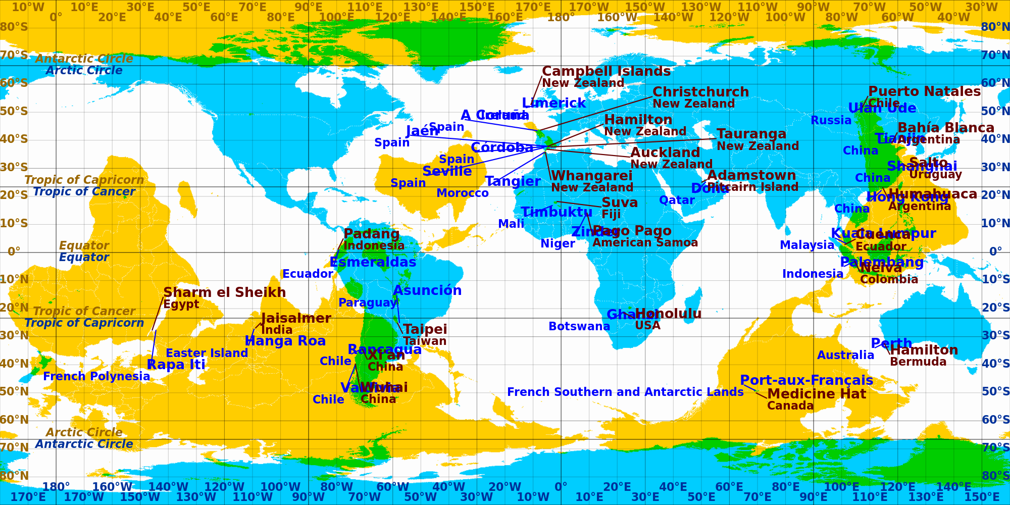
It’s called an antipodes map. There are much nicer ones, but I felt this one illustrated the point best.
Having a hard time wrapping my head around why the “opposite side” is upside down. Wouldn’t you just wrap-around slide the map 180° if you wanted a straight-line-through-the-center opposite side overlay? For example, according to this, what’s on the opposite side of the Earth from Antarctica is also Antarctica. Additionally, for it to be accurate, would you not have to use a different projection, like Dyson or Butterfly?
Edited for clarification.
Imagine it on a globe, then imagine a rod going through point A, passing the center of the globe, and coming out point B. That will give you this map, which is the opposite side of the world.
The blue and yellow maps are flipped because they are on opposite sides.
The green parts are where opposite sides line up (through the center).
The “two” Antarcticas aren’t on opposite sides of the same globe, the Antarctica (blue) lines up with the opposite (yellow) northern Greenland (overlap in green). Just like the blue Greenland mainly overlaps the yellow Antarctica showing green.
Just find a spot on the blue map, and then look at the yellow map to see what’s on the opposite side (it looks reversed since you are seeing that other map from below.)
Oh. OK, right, there’s an Antarctica on the top asked the bottom, which means the no-land-mass North Pole overlays Antarctica.
OK, I see it now, thanks.
I still think this would be nicely done as a butterfly projection; I’m still uncertain about whether the distortion of the projection would affect overlap accuracy. OT1H, N/S are equally distorted, so maybe it all washes out? OTOH, I’m suspicious of Mercator projections. Do you know?
The Mercator projection only distorts N/S, and the distortion is symmetrical about the equator. So it shouldn’t make a difference in this case. since corresponding points on both the right side up and upside down map are equidistant from the equator.
I’m also pretty disappointed by how few places have land exactly opposite them.
That’s what happens when the planet’s surface is 2/3 water. The Pacific Ocean be big, yo.
Reality has shitty worldbuilding
But it’s true that they’re aligned, you can actually trace a straight line from one to the other. That can’t be a coincidence!
Not just a line, a great circle!
Not just a great circle, but a fuckin’ awesome one.
Mehhh, I’ve seen better circles. Hell, I once saw a perfect circle, at Gund Arena in Cleveland
Confirmed, we live on a globe on someone’s desk and the pyramids are where we connect to the stand
That’s also a good depiction of the land/water hemispheric divide
Gotta dig through Chile to get to China. Elon and your dumb Boring Co., wya?


